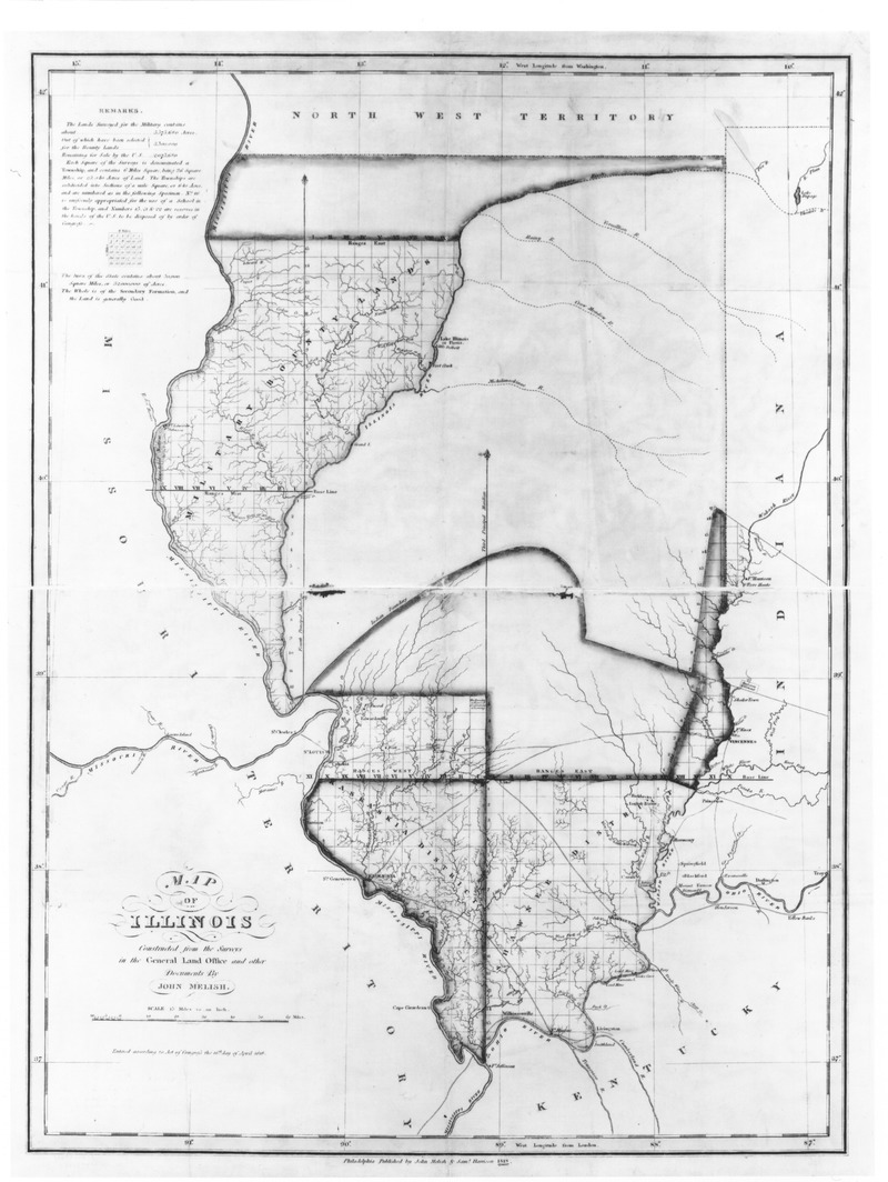
This map, provided by the Chicago History Museum, depicts Illinois at the time that it became the twenty-first state. In 1809 the area that became the state of Illinois was organized as the Illinois territory, with its capital at Kaskaskia. That city is visible on this map on Illinois’ southwestern border, across the Mississippi River from St. Genevieve, Missouri. Kaskaskia remained the capital of Illinois for a year, until the government removed to Vandalia, some 120 miles to the northeast. Vandalia was a very small town, not even represented on the above map, but Kaskaskia had proved unsuitable as a seat of government due to the Mississippi’s persistent threat of flooding. Vandalia also promised a more central location for a state eager to grow toward the north and east. As the map shows, much of what is now the most heavily-populated part of the state of Illinois had not even been divided into quarter sections, much less counties, at the time of statehood.
The Illinois country was not settled by parties moving across the land from east to west. In a time of very few roads, this would have been an extremely difficult task. Instead, immigrants came to Illinois by way of the Ohio and Mississippi Rivers, moving largely from south to north. The parts of this map depicted as settled, organized territory were, and are, largely inhabited by people who came to Illinois from Virginia, Kentucky and Tennessee. The wedge of land making up Illinois’ westernmost parts was also settled by way of river travel, but it was unique in that it had been set aside by Congress for settlement by veterans of the War of 1812. Note that it is identified on the map as “Military Bounty Land.”
Settlers did not come to northern, central and eastern Illinois in large numbers until the completion of the Erie Canal in 1825 made that land more accessible by way of the Great Lakes and Chicago. Today those portions of the state retain a significant population descended from immigrants who came to the state from New England and the middle states, like New York and Pennsylvania.
No comments:
Post a Comment